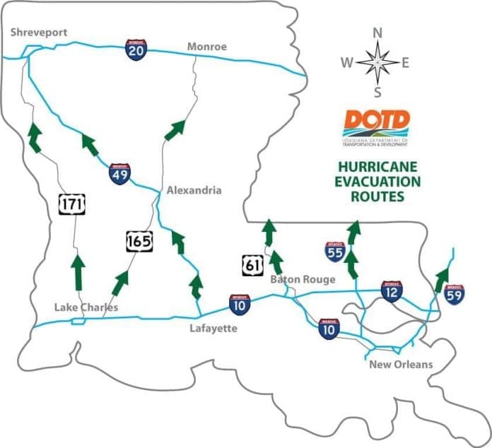
The Louisiana Department of Transportation has issued a Hurricane Evacuation Routes map that can assist motorists traveling along Interstate 10 or residents living along Louisiana’s Gulf coast.
The State of Louisiana Evacuation Plan goes into effect when any slow moving Category 3 and all Category 4 & 5 hurricanes pose a threat to our area. The goal of the State of Louisiana Evacuation Plan is to move everyone south of Interstate 10 to areas with higher elevation.
A decision for regional evacuation is made by Parish officials after conferring with the National Weather Service, the Governor’s Office of Homeland Security and Emergency Preparedness, Louisiana State Police, Department of Transportation and Development,
National Guard, local Sheriff’s Offices, and surrounding jurisdictions.
When appropriate, Contraflow lanes may be established on Interstate highways to aid in moving a large volume of motor vehicle traffic. Contraflow means the temporary redirection of vehicular traffic.
Before you travel, check 511la.org to see the latest road conditions and closures throughout the state.
On the road? Why not take us with you. All our websites are mobile-friendly. Visit our growing family of exit guides: I-4 Exit Guide, I-5 Exit Guide, I-10 Exit Guide, I-75 Exit Guide, and I-95 Exit Guide. Detailed exit service listings… discount lodging, camping, food, gas and more for every exit along the way!


