
The Arizona Department of Transportation (ADOT) reports their new Truck Parking Availability System (TPAS) along I-10 at the Ehrenberg, Bouse Wash, Texas Canyon and San Simon rest areas detects, monitors and provides real-time truck parking availability information to commercial truck drivers, dispatchers and other interested motorists.
The system is part of the I-10 Corridor Coalition’s I-10 TPAS initiative, a $13.7 million effort sponsored by the U.S. Department of Transportation to provide truck drivers and dispatchers with real-time truck parking information on I-10 in California, Arizona, New Mexico and Texas.
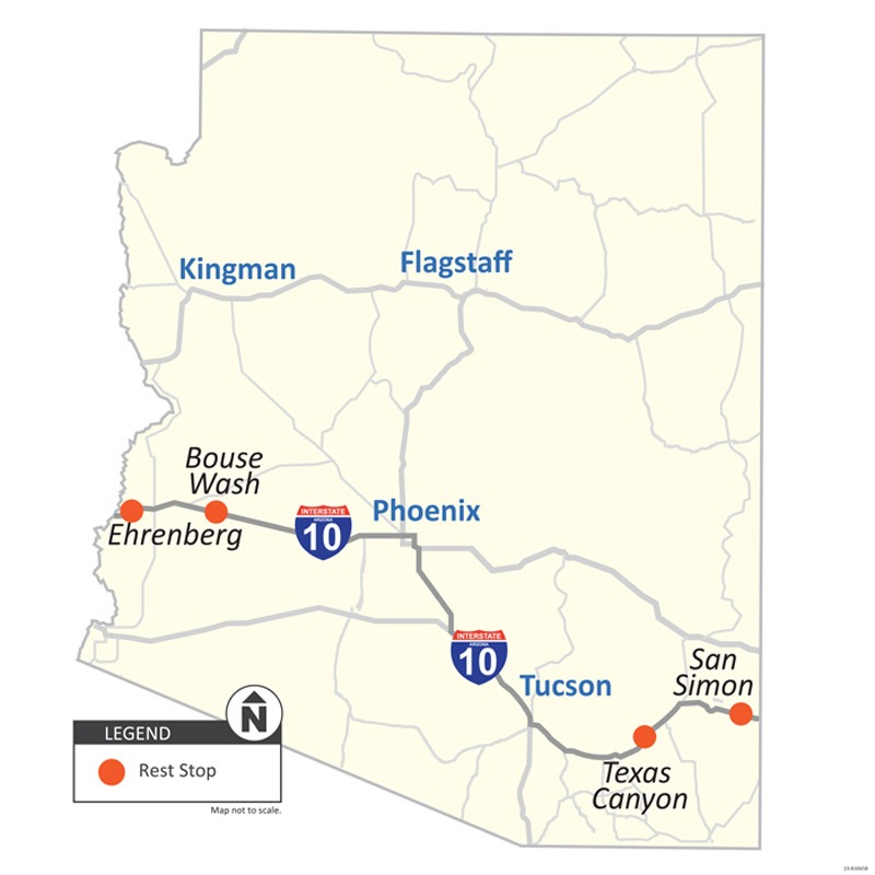
Current TPAS Locations
The TPAS is located at four rest areas on Interstate 10.
- Ehrenberg Rest Area serves traffic in both directions on I-10 between mileposts 4 and 5. This rest area is on the border of California, 4 miles east of Blythe. The nearest community is Quartzsite, located about 13 miles to the east.
- Bouse Wash Rest Area serves traffic in both directions on I-10 at milepost 53. This rest area is approximately 100 miles west of Phoenix. The nearest large community is Vicksburg located about 7 miles to the west.
- Texas Canyon Rest Area serves traffic in both directions on I-10 between mileposts 320 and 321. This rest area is about 70 miles east of Tucson. The nearest large community is Benson about 20 miles to the west and Willcox about 20 miles to the east.
- San Simon Rest Area serves traffic in both directions on I-10 at milepost 388. This southeastern rest area is located on the border of New Mexico. The nearest large community is Lordsburg New Mexico about 20 miles to the east and San Simon about 9 miles to the west.
Real Time Parking Updates
The Truck Parking Availability System (TPAS) delivers real-time data that enables truck drivers to secure appropriate resting locations, thereby avoiding the use of non-designated parking areas.
ADOT successfully implemented a $2.8 million advanced system at the Ehrenberg and Bouse Wash rest areas, catering to eastbound and westbound traffic between the Valley and California. Additionally, this initiative extends to the Texas Canyon and San Simon rest areas, effectively supporting both directions of Interstate 10 in southeastern Arizona.
Monitoring systems effectively capture real-time parking availability and disseminate this data to electronic signage as well as to third-party applications utilized by truck drivers.
What’s happening on Interstate 10 RIGHT NOW! I-10 Real-time traffic information for selected cities along I-10. Maps show updates on road construction, traffic accidents, travel delays and the latest traffic speeds. Traffic cameras show congestion at a glance. Visit I-10 Traffic.
The I-10 Exit Guide is the Internet’s largest and most complete website dedicated to Interstate 10 travelers. Find detailed exit service listings… lodging, camping, food, gas and more for every exit from California to Florida!
On the road? Why not take us with you. The I-10 Exit Guide is mobile-friendly and totally FREE. No App Required.
Traveling another route? Visit our growing family of exit guides: I-4 Exit Guide, I-5 Exit Guide, I-10 Exit Guide, I-75 Exit Guide, I-80 Exit Guide and I-95 Exit Guide. Detailed exit service listings… discount lodging, camping, food, gas and more for every exit along the way!
")

